Point of interest nearby Clínica da base do Kwanda
Angola
Point of interest nearby Clínica da base do Kwanda
Clínica da base do Kwanda
V8GJ+982, Soyo, Angola
contacts phone
:
+244
Latitude:
-6.1241099
, Longitude:
12.3307713
larger map & directions
read more
nearest Point of interest
250 m
Restaurante Hotel kwanda
V8GM+86F, Unnamed Road, Santo António do Zaire
Restaurant
Food
Point of interest
Establishment
read more
446 m
Kwanda Hotel, Soyo, Zaire, Angola
Kwanda Base, Santo António do Zaire
Lodging
Point of interest
Establishment
read more
684 m
Kwanda Base
Unnamed Road, Santo António do Zaire
Lodging
Point of interest
Establishment
read more
733 m
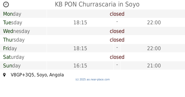
KB PON Churrascaria
V8GP+3Q5, Soyo
Restaurant
Food
Point of interest
Establishment
read more
841 m
Condomínio Belmira Bar família Vasco
Kukala kiaku, Rua direita do Porto, Santo António do Zaire
Lodging
Point of interest
Establishment
read more
1.945 km
Condomínio Rina Guest House
V8GX+FQ6, Soyo
Lodging
Point of interest
Establishment
read more
2.839 km
CASA ALVARO
ALVARO CRISTINA SERVICE DEEP, Santo António do Zaire
Lodging
Point of interest
Establishment
read more
2.953 km
João Marcelino Nenkamba
V9G4+8XX, Soyo
Lodging
Point of interest
Establishment
read more
3.017 km
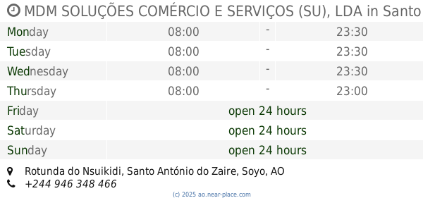
MDM SOLUÇÕES COMÉRCIO E SERVIÇOS (SU), LDA
Rotunda do Nsuikidi, Santo António do Zaire
Restaurant
Food
Point of interest
Establishment
read more
3.017 km
Angola LNG Project
Soyo
Point of interest
read more
3.017 km
Zaire Soyo
V952+HRQ, Soyo
Lodging
Point of interest
Establishment
read more
3.017 km
helena roza
cp.00340, Santo António do Zaire
Restaurant
Food
Point of interest
Establishment
read more
3.017 km
ENZOSIRA
KINDOMBELE/WOLO 2 Quarteirão B, Santo António do Zaire
Lodging
Point of interest
Establishment
read more
3.017 km
Noslen Laboratorio de Analise clinicas
V952+HRQ, Soyo
Hospital
Health
Point of interest
Establishment
read more
3.124 km
Hotel Nempanzu II
casa sem numero, Rua do Matadouro, Santo António do Zaire
Lodging
Point of interest
Establishment
read more
📑
all categories
Accounting
Administrative area level 1
Administrative area level 2
Airport
Amusement park
Atm
Bakery
Bank
Bar
Beauty salon
Book store
Bus station
Cafe
Campground
Car dealer
Car rental
Car repair
Car wash
Casino
Cemetery
Church
Clothing store
Convenience store
Courthouse
Dentist
Department store
Doctor
Electrician
Electronics store
Embassy
Establishment
Finance
Fire station
Florist
Food
Funeral home
Furniture store
Gas station
General contractor
Grocery or supermarket
Gym
Hair care
Hardware store
Health
Home goods store
Hospital
Insurance agency
Jewelry store
Laundry
Lawyer
Library
Liquor store
Local government office
Locality
Lodging
Meal delivery
Meal takeaway
Mosque
Movie theater
Moving company
Museum
Natural feature
Neighborhood
Night club
Park
Parking
Pet store
Pharmacy
Physiotherapist
Place of worship
Point of interest
Police
Post office
Premise
Real estate agency
Restaurant
Route
Rv park, camping
School
Shoe store
Shopping mall
Spa
Stadium
Storage
Store
Supermarket
Synagogue
Taxi stand
Train station
Transit station
Travel agency
University
Veterinary care
sublocality level 1
↑