Point of interest nearby Pescaria Iemanja
Coronavirus disease (COVID-19) Situation
confirmed cases
107327
deaths
1937
Angola
Point of interest nearby Pescaria Iemanja
Pescaria Iemanja
Baia Farta, Angola
contacts phone
:
+244 272 280 454
Latitude:
-12.6197113
, Longitude:
13.2126153
larger map & directions
read more
nearest Point of interest
1.436 km
Instituto Médio De Ciências Policiais
Baia Farta
Point of interest
read more
2.068 km
Pesca Fresca Limitada
Unnamed Road, Baía Farta
Point of interest
read more
2.273 km
Sede, Lda
Baia Farta
Point of interest
read more
41.742 km
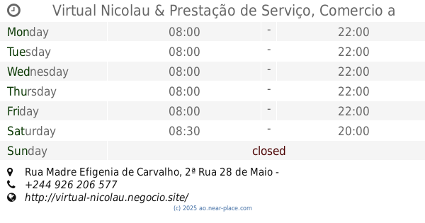
Virtual Nicolau & Prestação de Serviço, Comercio a retalho,
Rua Madre Efigenia de Carvalho, 2ª Rua 28 de Maio - Zona Comercial, Catumbela
Point of interest
read more
43.45 km
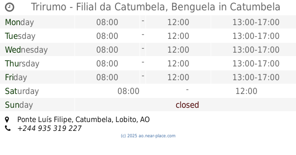
Trirumo - Filial da Catumbela, Benguela
Pólo de Desenvolvimento Industrial da Catumbela, Ponte Luís Filipe, Catumbela
Point of interest
read more
43.51 km
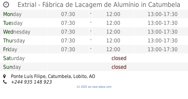
Extrial - Fábrica de Lacagem de Alumínio
Pólo de Desenvolvimento Industrial da Catumbela, Ponte Luís Filipe, Catumbela
Point of interest
read more
43.681 km
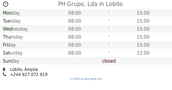
PH Grupo, Lda
Lobito
Point of interest
read more
43.716 km
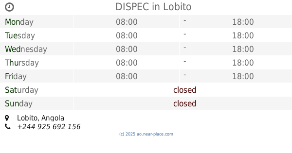
DISPEC
Lobito
Point of interest
read more
43.931 km
Acail Angola ( Lobito )
Lobito
Point of interest
read more
44.09 km
Auto Sueco
Lobito
Point of interest
read more
44.263 km
ENOC OIL
Lobito
Point of interest
read more
44.635 km
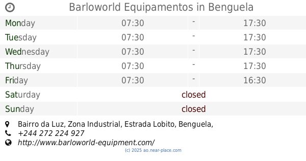
Barloworld Equipamentos
Bairro da Luz, Zona Industrial, Estrada Lobito, Benguela
Point of interest
read more
46.205 km
Multi-Net, Lda
Rua Sousa Coutinho, Lobito
Point of interest
read more
46.849 km
Sede Social da Sonamet
Lobito
Point of interest
read more
46.865 km
Grupo SGO-Transportes, Lobito
Av.NORTON DE MATOS, Lobito
Point of interest
read more
46.932 km
ChanTiff - Informática
Lobito
Point of interest
read more
47.103 km
Sonamet Industrial
Lobito
Point of interest
read more
47.111 km
Sonamet - Headquarters
Caponte, Lobito
Point of interest
read more
47.116 km
AngoBetumes
Lobito
Point of interest
read more
47.286 km
Sede FPKU
Lobito
Point of interest
read more
📑
all categories
Accounting
Administrative area level 1
Administrative area level 2
Airport
Amusement park
Atm
Bakery
Bank
Bar
Beauty salon
Book store
Bus station
Cafe
Campground
Car dealer
Car rental
Car repair
Car wash
Casino
Cemetery
Church
Clothing store
Convenience store
Courthouse
Dentist
Department store
Doctor
Electrician
Electronics store
Embassy
Establishment
Finance
Fire station
Florist
Food
Funeral home
Furniture store
Gas station
General contractor
Grocery or supermarket
Gym
Hair care
Hardware store
Health
Home goods store
Hospital
Insurance agency
Jewelry store
Laundry
Lawyer
Library
Liquor store
Local government office
Locality
Lodging
Meal delivery
Meal takeaway
Mosque
Movie theater
Moving company
Museum
Natural feature
Neighborhood
Night club
Park
Parking
Pet store
Pharmacy
Physiotherapist
Place of worship
Point of interest
Police
Post office
Premise
Real estate agency
Restaurant
Route
Rv park, camping
School
Shoe store
Shopping mall
Spa
Stadium
Storage
Store
Supermarket
Synagogue
Taxi stand
Train station
Transit station
Travel agency
University
Veterinary care
sublocality level 1
↑