Establishment nearby Soyo Municipal Hospital
Angola
Establishment nearby Soyo Municipal Hospital
Soyo Municipal Hospital
Soyo, Angola
contacts phone
:
+244
Latitude:
-6.1315
, Longitude:
12.3701
larger map & directions
read more
nearest Establishment
48 m
Banco Caixa Geral
V99C+63Q, Soyo
Bank
Finance
Point of interest
Establishment
read more
115 m
Hospedaria. Kifuma
RUA DIREITA DO AEROPORTO CASA Nº. 299, Santo António do Zaire
Lodging
Point of interest
Establishment
read more
216 m
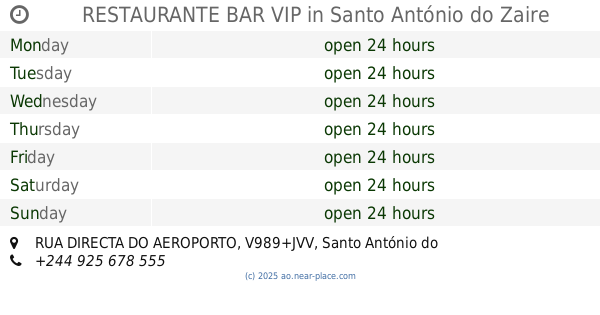
RESTAURANTE BAR VIP
V989+JVV, RUA DIRECTA DO AEROPORTO, Santo António do Zaire
Night club
Cafe
Store
Point of interest
Food
Establishment
read more
429 m
Angop - Agência Angola Press, Soyo - Zaire
EN100, Santo António do Zaire
Post office
Finance
Point of interest
Establishment
read more
479 m
Nenbumba Residencial
Soyo
Lodging
Point of interest
Establishment
read more
498 m
Licy
V9C8+QV2, Soyo
Restaurant
Point of interest
Food
Establishment
read more
623 m
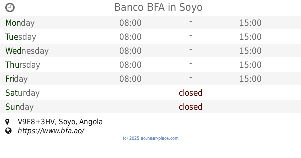
Banco BFA
V9F8+3HV, Soyo
Bank
Finance
Point of interest
Establishment
read more
680 m
JEMBAS
V9F8+CMP, Soyo
Lodging
Point of interest
Establishment
read more
695 m
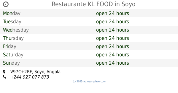
Restaurante KL FOOD
V97C+2RF, Soyo
Restaurant
Point of interest
Food
Establishment
read more
716 m
Hotel Jacilina
V9F8+GJR, Soyo
Lodging
Point of interest
Establishment
read more
873 m
Correios e Telégrafos
EN100, Santo António do Zaire
Post office
Finance
Point of interest
Establishment
read more
985 m
Hotel Casmad
V9F7+G5G, Casmad, Santo António do Zaire
Lodging
Point of interest
Establishment
read more
1.051 km
Banco BNI
V9G7+7H6, Unnamed Road, Santo António do Zaire
Bank
Finance
Point of interest
Establishment
read more
1.21 km
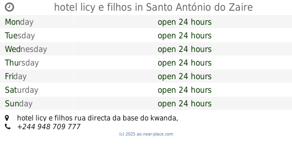
hotel licy e filhos
hotel licy e filhos rua directa da base do kwanda, Santo António do Zaire
Lodging
Point of interest
Establishment
read more
1.287 km
Cantinho N'GA TONHA
V9G6+FHM, hotel licy e filhos rua directa da base do kwanda, Santo António do Zaire
Restaurant
Food
Point of interest
Establishment
read more
📑
all categories
Accounting
Administrative area level 1
Administrative area level 2
Airport
Amusement park
Atm
Bakery
Bank
Bar
Beauty salon
Book store
Bus station
Cafe
Campground
Car dealer
Car rental
Car repair
Car wash
Casino
Cemetery
Church
Clothing store
Convenience store
Courthouse
Dentist
Department store
Doctor
Electrician
Electronics store
Embassy
Establishment
Finance
Fire station
Florist
Food
Funeral home
Furniture store
Gas station
General contractor
Grocery or supermarket
Gym
Hair care
Hardware store
Health
Home goods store
Hospital
Insurance agency
Jewelry store
Laundry
Lawyer
Library
Liquor store
Local government office
Locality
Lodging
Meal delivery
Meal takeaway
Mosque
Movie theater
Moving company
Museum
Natural feature
Neighborhood
Night club
Park
Parking
Pet store
Pharmacy
Physiotherapist
Place of worship
Point of interest
Police
Post office
Premise
Real estate agency
Restaurant
Route
Rv park, camping
School
Shoe store
Shopping mall
Spa
Stadium
Storage
Store
Supermarket
Synagogue
Taxi stand
Train station
Transit station
Travel agency
University
Veterinary care
sublocality level 1
↑