Establishment nearby TryCup Hospedaria e Turismo
Angola
Establishment nearby TryCup Hospedaria e Turismo
TryCup Hospedaria e Turismo
Q5Q2+3V, Namibe, Angola
contacts phone
:
+244 923 457 658
Latitude:
-15.2123627
, Longitude:
12.1522063
larger map & directions
read more
nearest Establishment
297 m
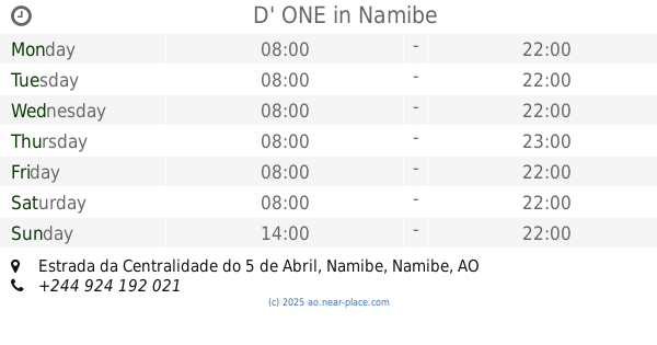
D' ONE
Estrada da Centralidade do 5 de Abril, Namibe
Restaurant
Point of interest
Food
Establishment
read more
331 m
Pensão JPP & Filhos
estrada do Arena, Rua 11 de Novembro, Namibe
Lodging
Point of interest
Establishment
read more
441 m
Meraki Villa
12, Namibe
Lodging
Point of interest
Establishment
read more
546 m
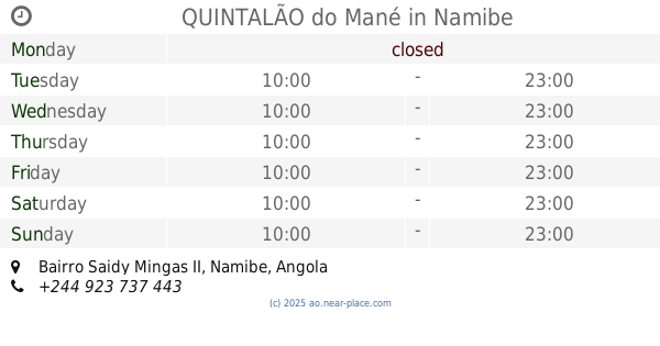
QUINTALÃO do Mané
Bairro Saidy Mingas II, Namibe
Restaurant
Point of interest
Food
Establishment
read more
909 m
Hamburgaria Cantinho da Sara
Q4HX+XPH, Unnamed Road, Namibe
Cafe
Food
Point of interest
Establishment
read more
926 m
Casa de Família
Q4WX+7W9, Namibe
Lodging
Point of interest
Establishment
read more
960 m
Centro Materno Infantil
Q4QV+R9H, Namibe
Hospital
Health
Point of interest
Establishment
read more
992 m
Maternidade do Namibe
Q4QV+J64, Unnamed Road,, Namibe
Hospital
Health
Point of interest
Establishment
read more
996 m
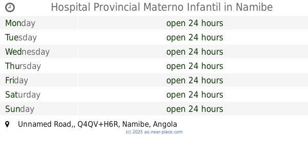
Hospital Provincial Materno Infantil
Q4QV+H6R, Unnamed Road,, Namibe
Hospital
Point of interest
Health
Establishment
read more
1.002 km
A Chaminé Restaurante Residencial
Q4JW+6GX, Namibe
Restaurant
Food
Point of interest
Establishment
read more
1.065 km
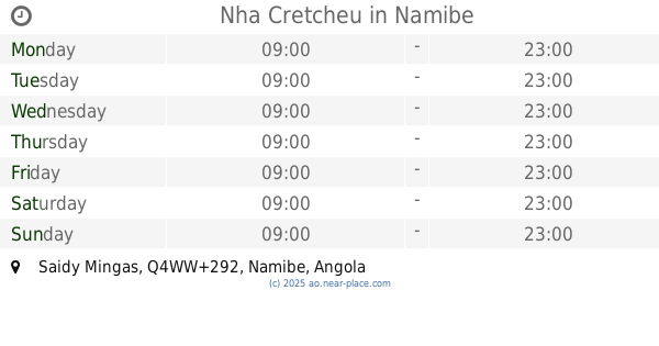
Nha Cretcheu
Q4WW+292, Saidy Mingas, Namibe
Restaurant
Food
Point of interest
Establishment
read more
1.344 km
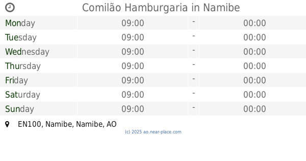
Comilão Hamburgaria
Q4WV+G93, EN100, Namibe
Cafe
Food
Point of interest
Establishment
read more
1.367 km
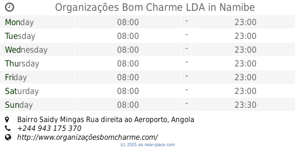
Organizações Bom Charme LDA
Bairro Saidy Mingas Rua direita ao Aeroporto
Restaurant
Point of interest
Food
Establishment
read more
1.54 km
Skina Place
R523+F53, B. Cassanje, Namibe
Restaurant
Food
Point of interest
Establishment
read more
2.027 km
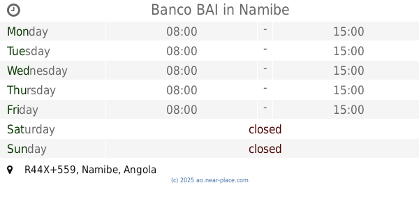
Banco BAI
R44X+559, Namibe
Bank
Finance
Point of interest
Establishment
read more
📑
all categories
Accounting
Administrative area level 1
Administrative area level 2
Airport
Amusement park
Atm
Bakery
Bank
Bar
Beauty salon
Book store
Bus station
Cafe
Campground
Car dealer
Car rental
Car repair
Car wash
Casino
Cemetery
Church
Clothing store
Convenience store
Courthouse
Dentist
Department store
Doctor
Electrician
Electronics store
Embassy
Establishment
Finance
Fire station
Florist
Food
Funeral home
Furniture store
Gas station
General contractor
Grocery or supermarket
Gym
Hair care
Hardware store
Health
Home goods store
Hospital
Insurance agency
Jewelry store
Laundry
Lawyer
Library
Liquor store
Local government office
Locality
Lodging
Meal delivery
Meal takeaway
Mosque
Movie theater
Moving company
Museum
Natural feature
Neighborhood
Night club
Park
Parking
Pet store
Pharmacy
Physiotherapist
Place of worship
Point of interest
Police
Post office
Premise
Real estate agency
Restaurant
Route
Rv park, camping
School
Shoe store
Shopping mall
Spa
Stadium
Storage
Store
Supermarket
Synagogue
Taxi stand
Train station
Transit station
Travel agency
University
Veterinary care
sublocality level 1
↑