Point of interest nearby iu Hotel Benguela
Angola
Point of interest nearby iu Hotel Benguela
iu Hotel Benguela
Avenida Doutor António Agostinho Neto, Benguela, Benguela, AO Angola
contacts phone
:
+244 929 102 277
Latitude:
-12.6010913
, Longitude:
13.4021358
larger map & directions
read more
nearest Point of interest
189 m
Bom Preço
CC23+38J, Benguela
Supermarket
Grocery or supermarket
Store
Food
Point of interest
Establishment
read more
662 m
Família Chiconde
9CX5+97Q, Candumbo
Lodging
Point of interest
Establishment
read more
774 m
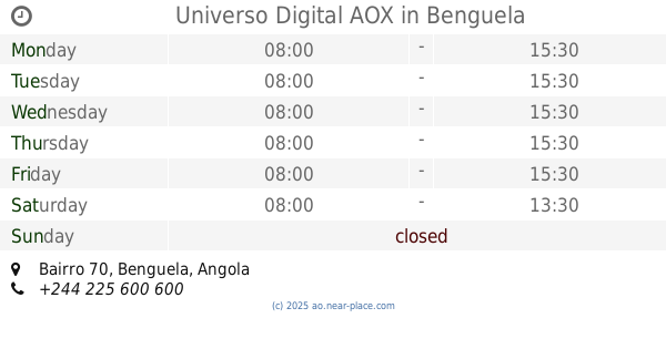
Universo Digital AOX
Bairro 70, Benguela
Bank
Finance
Point of interest
Establishment
read more
774 m
Siac Benguela
9CW5+JGH, Benguela
Bank
Finance
Point of interest
Establishment
read more
1.394 km
Residencial MELSAN
Rua Paiva Couceiro 28 de Maio
Lodging
Point of interest
Establishment
read more
1.404 km
BFA Coringe
C96X+GVG, Benguela
Bank
Finance
Point of interest
Establishment
read more
1.778 km
Marisqueira Sani
CC74+V24, Benguela
Restaurant
Food
Point of interest
Establishment
read more
1.844 km
Kanzela Albergaria e Restaurantte
C97V+FQQ, Bairro da Gôa, Rua General João de Almeida, Benguela
Lodging
Point of interest
Establishment
read more
1.928 km
Restaurante Fredmerk
CC75+RVV, Rua: infante Don Henriques Benguela - Angola, Benguela
Restaurant
Food
Point of interest
Establishment
read more
1.952 km
Odeth
CC58+QJR, Benguela
Cafe
Food
Point of interest
Store
Establishment
read more
1.952 km
nova fumetal
Benguela
Supermarket
Grocery or supermarket
Food
Point of interest
Store
Establishment
read more
1.952 km
Brasileirão
CC58+QJR, Benguela
Lodging
Point of interest
Establishment
read more
1.952 km
Kinda foods
CC58+QJR, Benguela
Restaurant
Food
Point of interest
Establishment
read more
2.008 km
Banco Millennium Atlântico
Baía Farta, Bairro Calohombo, Benguela, Benguela
Bank
Finance
Point of interest
Establishment
read more
2.079 km
Dispensário Anti-Tuberculose
CC86+5F6, Benguela
Hospital
Health
Point of interest
Establishment
read more
📑
all categories
Accounting
Administrative area level 1
Administrative area level 2
Airport
Amusement park
Atm
Bakery
Bank
Bar
Beauty salon
Book store
Bus station
Cafe
Campground
Car dealer
Car rental
Car repair
Car wash
Casino
Cemetery
Church
Clothing store
Convenience store
Courthouse
Dentist
Department store
Doctor
Electrician
Electronics store
Embassy
Establishment
Finance
Fire station
Florist
Food
Funeral home
Furniture store
Gas station
General contractor
Grocery or supermarket
Gym
Hair care
Hardware store
Health
Home goods store
Hospital
Insurance agency
Jewelry store
Laundry
Lawyer
Library
Liquor store
Local government office
Locality
Lodging
Meal delivery
Meal takeaway
Mosque
Movie theater
Moving company
Museum
Natural feature
Neighborhood
Night club
Park
Parking
Pet store
Pharmacy
Physiotherapist
Place of worship
Point of interest
Police
Post office
Premise
Real estate agency
Restaurant
Route
Rv park, camping
School
Shoe store
Shopping mall
Spa
Stadium
Storage
Store
Supermarket
Synagogue
Taxi stand
Train station
Transit station
Travel agency
University
Veterinary care
sublocality level 1
↑